How to use maps to promote tourism
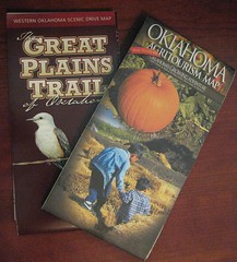 I think that tourism and driving tour maps are great tools for small town tourism. I picked up these two locally: the Great Plains Trail of Oklahoma and the Oklahoma Agritourism Map.
The hope is that with a map full of suggestions, visitors are more likely to string together several destinations. I don’t know if there are any scientific studies to show their results, but I’ll bet we can enhance them with some interactive online tools.
The most obvious interactive tool is a mashup map online. Here’s the online map for Agritourism. Now, a smaller region on a budget probably can’t invest in this kind of interface, though it is lovely! What can you do with little or no budget? Here are three suggestions:
- Take your digital camera and shoot simple, clear one minute videos of attractions. Use TubeMogul to post them to a multitude of sharing sites.
- Build Facebook Fan Page or Ning community, post your info, and let your travelers share their own photos and stories.
- Set up a Flickr Group for photos from your trail.
- Be sure to link all of these to your main website and to share the links on your map.
Now, how about some accessories? 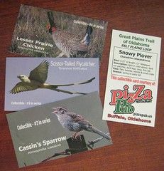 The Great Plains Trail is a wildlife trail, and the map group also created some collector cards featuring different birds. How could we build an online component to these neat little cards?
- Add a website address. Tell more about the card, and where to get more.
- Give GPS coordinates of the attractions, in this case, driving loops on the trail.
- Make a forum post on your Facebook Page or Ning community for people to comment and register their cards. Encourage them to share their travel story.
As always, you have the best ideas. How would you add online interaction to paper maps? What other ideas do you have?
New to SmallBizSurvival.com? Take the Guided Tour. Like what you see? Get our updates.
- About the Author
- Latest by this Author

Becky started Small Biz Survival in 2006 to share rural business and community building stories and ideas with other small town business people. She and her husband have a small cattle ranch and are lifelong entrepreneurs. Becky is an international speaker on small business and rural topics.

I stumbled upon this blog article. I agree with your point of view. Have you used Google Maps? It’s a free tool that lets the creator have complete control over what attractions, hotels, restaurants, parks etc. you choose to list. If you choose to make your maps available to the public they’ll actually show up in organic search results. And Google will let you create a profile with opportunities to link to your own website and provide contact information. Hope that helps. If you have any questions or want more information don’t hesitate to contact me directly.
Cheers,
Meilee Anderson
Seattle Southside
206-575-2489
W: seattlesouthside.com
T: @seattlesouthsid
Meilee, thanks for the info on Google Maps. I have used it, and it can be very powerful. It’s also a good complement to the other interactive tools we talked about. Glad you stopped in, and took time to comment, Meilee. Come back any time.
Becky – You might also want to think mobile, in this process as well. Here is a link to an example – http://winksite.mobi/xhtml/ms_fo_pg_l.cfm?susid=23670&fid=15633
Paul, you are absolutely right. And that is a great example. Mobile friendly walking tours = brilliant!
Hey Becky,
Is there a mobile app that will search Twitter like a Tweetdeck search? If businesses got in habit of putting city name in each Tweet, anyone with a cell phone could find out what was happening in your town right then as they were passing through.
Imagine pulling into your motel stop on a trip at dinner time. Instead of automatically heading to the Denny’s next door, you discover on your phone that six blocks to the east there’s a brew pub with a band and there are several people tweeting about how good the music is…
The possibilities for local merchants, if they adhere to generally acceptable Twitter etiquette, are unlimited.
I’ve searched headlines on Mashable, but so far haven’t narrowed down on such an app.
Found my answers at http://tinyurl.com/cmc9q6 – at least for iphone users.
Bobbie, you are on to something very good here. If we take a local events calendar to all the motel rooms, we should include not just the website for the online calendar, but also the Twitter account name for our town and our favorite hashtag. I know that Hutchinson, KS, frequently tags things #hutch. I’m thinking #AlvaOK is my new tag for local events tweets. :)
Renewing the Countryside developed an online interactive map tool to find trails and routes to find small businesses and family farms in rural Minnesota and other midwest states. Link: http://greenroutes.org
Great example, Katie. Thanks for sharing it.
Becky, I know this is an old post, but I launched an interactive map creation startup called Tripline (http://www.tripline.net) in 2010 and I thought you may want to have a look. Here’s an example of a walking tour: http://www.tripline.net/trip/Boston_Freedom_Trail_-7372323165121003A5DAFE17B4532314 and another of a list of places: http://www.tripline.net/trip/Best_L.A._Beginner_Surf_Spots-4250417710171003A0C4DE5F4E4115CC
Byron, thanks for the info. I’ll be taking a look.